







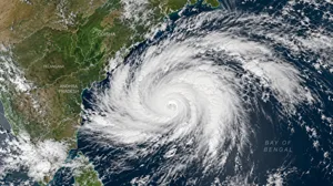
According to the IMD's October 27 forecast, the cyclone is expected to cross the Andhra Pradesh–Yanam coastline between Bapatla and Visakhapatnam, close to Yanam, during the morning of Wednesday, October 28, 2026. Maximum sustained winds of 115–125 kilometers per hour, gusting up to 140 km/h, are forecast during landfall.
With thousands of residents being evacuated and disaster-response agencies mobilized, Cyclone Arnab represents a significant weather emergency for India's eastern coastal region.
What is Cyclone Arnab ?
Cyclone Arnab is a tropical cyclone that developed over the Bay of Bengal in October 2026. It formed from an area of low atmospheric pressure that gradually intensified into a depression, deep depression and eventually a cyclonic storm.
The system strengthened further into a severe cyclonic storm and then a very severe cyclonic storm on October 26–27.
Tropical cyclones develop over warm ocean waters when moist air rises and creates an area of low pressure. As surrounding air moves inward, the system can begin rotating and organizing into bands of thunderstorms. Under favorable atmospheric conditions, it may intensify into a powerful storm.
Cyclone Arnab has followed this development process over the Bay of Bengal, with warm ocean waters and favorable atmospheric conditions supporting its intensification.
Cyclone Arnab 2026: Key information
Particulars Details Cyclone name Arnab Pronunciation Ornab Region West-central Bay of Bengal Cyclone formation 26 October, 2026 Classification Very severe Cyclonic Storm Forecast landfall 28 October, 2026 Expected landfall area Near Yanam, between Bapatla and Vishakhapatnam Sustained winds at landfall 115–125 km/h Maximum forecast gusts 140 km/h Main affected states Andhra Pradesh and Odisha Other potentially affected areas Telangana, Chhattisgarh, Jharkhand, Bihar and eastern Uttar Pradesh Warning authority India Meteorological Department
Cyclone Arnab latest update: October 27, 2026
According to the IMD bulletin issued on the morning of October 27, Cyclone Arnab was positioned over the west-central Bay of Bengal near latitude 15.9°N and longitude 84.8°E.
At approximately 5:30 AM IST, the cyclone was located:
- 260 km southeast of Visakhapatnam, Andhra Pradesh.
- 300 km east-southeast of Kakinada, Andhra Pradesh.
- 380 km south of Gopalpur, Odisha.
- 390 km east of Machilipatnam, Andhra Pradesh.
- 460 km east of Bapatla, Andhra Pradesh.
The storm was moving nearly westwards at approximately 22 km/h during the preceding six hours.
The IMD forecast that Arnab would move west-northwestwards until the evening of October 27 before turning northwestwards towards the Andhra Pradesh and Yanam coast.
Satellite imagery from India's INSAT-3DS weather satellite showed extensive cloud formations and intense thunderstorm activity associated with the system.
These positions represent observations from the specified bulletin, not the cyclone's continuously updated location.
When and where will Cyclone Arnab make landfall ?
The IMD's principal forecast places Cyclone Arnab's landfall along the Andhra Pradesh and Yanam coast, between Bapatla and Visakhapatnam, close to Yanam, during the forenoon of October 28.
A later regional report on October 27 suggested that landfall could occur earlier, between approximately 2 AM and 4 AM on October 28, citing Regional Weather Centre scientist Dr. Manorama Mohanty. However, the exact timing remains subject to changes in the cyclone's speed and direction.
What happens during landfall ?
Landfall occurs when the center of a tropical cyclone crosses the coastline. However, the strongest rainfall and damaging winds can begin several hours before the cyclone's center reaches land.
During landfall, coastal communities may experience intense rainfall, powerful gusts, falling trees, electricity failures and seawater entering low-lying areas.
Even after the cyclone moves inland and weakens, heavy rainfall and flooding can continue across affected districts.
States likely to be affected by Cyclone Arnab
1. Andhra Pradesh: Highest risk of direct impact
Andhra Pradesh is expected to experience the cyclone's most severe effects because the forecast track takes the storm towards its coastline.
Coastal locations including Visakhapatnam, Kakinada, Yanam, Machilipatnam and surrounding districts face risks from destructive winds, torrential rainfall and coastal inundation.
Possible impacts include damage to houses, roads and power lines; uprooted trees; flooding of residential and agricultural areas; disruption to transport; and damage to fishing infrastructure.
The intensity of these impacts will vary depending on the final landfall location, storm structure, local terrain and preparedness.
2. Odisha: Heavy rainfall and strong winds
Southern Odisha is also under significant weather warnings, particularly coastal and adjoining inland districts.
Areas around Gopalpur and neighboring coastal communities may experience heavy to extremely heavy rainfall, strong gusts and rough seas.
Authorities have been preparing shelters and evacuation arrangements for vulnerable communities.
3. Telangana and Chhattisgarh
As the system moves inland, its associated rain bands may bring heavy rainfall to Telangana and parts of southern and central Chhattisgarh.
Although the cyclone is expected to weaken after landfall, its remnants may continue producing substantial rainfall.
Low-lying settlements, agricultural land and areas with poor drainage could face localized flooding.
4. Jharkhand, Bihar and eastern Uttar Pradesh
Rainfall associated with the cyclone and its inland circulation may also affect parts of eastern and northern India.
The National Crisis Management Committee's preparedness review identified Bihar and eastern Uttar Pradesh among areas requiring advance rainfall alerts.
The exact extent of rainfall in these regions will depend on the cyclone's movement after landfall.
Cyclone Arnab rainfall warning
The IMD has warned of heavy to extremely heavy rainfall across parts of coastal Andhra Pradesh and southern Odisha through October 29. Extremely heavy rainfall can create several problems, especially when intense precipitation falls over a short period.
Urban areas may experience waterlogging, blocked roads and overflowing drainage systems. Rural areas may face crop damage, flooded fields and disruption to transport connections.
Residents living near rivers, streams and drainage channels should be particularly cautious because water levels can rise rapidly during intense rainfall.
Cyclone Arnab wind speed and storm intensity
Cyclone Arnab has been classified as a very severe cyclonic storm under the IMD's North Indian Ocean classification system. The classification is based primarily on maximum sustained wind speed.
Cyclone Category Sustained wind speed Cyclonic Storm 62-88 km/h Severe Cyclonic Storm 89-117 km/h Very Severe Cyclonic Storm 118–166 km/h Extremely Severe Cyclonic Storm 167–221 km/h Super Cyclonic Storm 222 km/h or higher
Arnab's forecast sustained winds of 115–125 km/h at landfall place its expected intensity around the boundary between severe and very severe cyclonic storm categories, while its current classification is very severe.
These winds can damage weak structures, uproot trees, break electrical lines and make outdoor movement extremely dangerous.
Storm surge warning: Why coastal flooding is a major concern
One of the most dangerous aspects of a tropical cyclone is storm surge.
Storm surge is an abnormal rise in seawater level caused primarily by strong winds pushing ocean water towards the coast, along with the effects of low atmospheric pressure.
Reports citing IMD warnings indicate the possibility of a storm surge of approximately 1–2 meters above the normal astronomical tide in vulnerable sections of the Andhra Pradesh coastline.
The actual flooding risk depends on coastal elevation, the timing of high tide, wind direction and the storm's final track.
Storm surge can flood coastal settlements, damage fishing boats and contaminate freshwater supplies. People in exposed, low-lying areas should follow evacuation instructions rather than relying on the forecast surge height alone.
Government preparations and evacuation measures
Indian authorities have initiated large-scale preparations to reduce the risk of casualties and infrastructure damage.
According to an Associated Press report published on October 27, at least 89,000 people had been evacuated from vulnerable coastal areas of Andhra Pradesh.
The report also stated that authorities had established more than 2,000 cyclone shelters across 20 districts, secured over 30,000 fishing boats and deployed nearly 1,100 medical teams. More than 12 million people live along the cyclone's projected path.
In neighboring Odisha, authorities were preparing to evacuate approximately 48,000 people from areas considered vulnerable to the storm.
The National Crisis Management Committee (NCMC) also reviewed the preparedness of central and state agencies on October 26. The review covered evacuation planning, emergency shelters, disaster-response deployment, essential services and coordination between authorities.
The NDRF, armed forces and Indian Coast Guard were among the agencies mobilizing resources for possible rescue and relief operations.
Impact on transportation, electricity and essential services
Cyclone Arnab is expected to disrupt normal activities in parts of the eastern coastal region.
Railways and roads: Some train services have already been cancelled as a precaution. Strong winds, waterlogging, fallen trees and damaged infrastructure could disrupt road and rail connectivity.
Air travel: Flights may be delayed or cancelled at affected airports depending on wind conditions and operational safety assessments.
Electricity: Strong winds can damage power distribution lines, transformers and utility poles. Electricity providers have been directed to prepare for disruptions and restoration work.
Schools and offices: Local administrations may order temporary closures in districts facing severe weather. Such decisions should be verified through district-level official announcements.
Fishing activities: Fishermen have been advised to avoid dangerous sections of the Bay of Bengal and affected coastal waters during October 26–29.
Why was the cyclone named Arnab ?
The name Arnab was proposed by Bangladesh under the tropical cyclone naming system coordinated by the World Meteorological Organization (WMO) and the United Nations Economic and Social Commission for Asia and the Pacific (ESCAP) Panel on Tropical Cyclones.
Arnab is commonly associated with the Bengali word meaning sea or ocean.
The official cyclone naming list, adopted in April 2020, includes 169 names contributed by 13 countries.
These countries are Bangladesh, India, Iran, Maldives, Myanmar, Oman, Pakistan, Qatar, Saudi Arabia, Sri Lanka, Thailand, the United Arab Emirates and Yemen.
Each country submitted 13 names, which are used in a predetermined sequence when qualifying cyclones develop over the North Indian Ocean.
The IMD's Regional Specialized Meteorological Centre in New Delhi is responsible for assigning names to tropical cyclones in the Bay of Bengal and Arabian Sea.
Cyclone names help meteorologists, disaster-response authorities and the public identify storms clearly, particularly when multiple weather systems are active.
Why is the Bay of Bengal prone to powerful cyclones ?
The Bay of Bengal is one of the most cyclone-prone regions affecting India. Several geographical and atmospheric factors contribute to cyclone formation and intensification in the region.
Warm sea surface temperatures: Tropical cyclones obtain much of their energy from warm ocean water. High sea surface temperatures can provide favorable conditions for development.
High atmospheric moisture: Moist air rising from the ocean supports deep cloud formation and intense thunderstorms.
Low vertical wind shear: When winds do not change dramatically with altitude, a cyclone's circulation can remain organized and strengthen.
Coastal geography: The shape of the Bay of Bengal and its surrounding coastlines can increase storm-surge vulnerability in certain low-lying coastal areas.
Seasonal conditions: The pre-monsoon and post-monsoon periods, particularly April–May and October–November, are important cyclone seasons in the North Indian Ocean.
These factors help explain why states such as Odisha, Andhra Pradesh, Tamil Nadu and West Bengal have historically faced major cyclonic storms.
Cyclone Arnab safety precautions
People living in areas covered by official cyclone warnings should take precautions before the strongest winds and rainfall arrive.
- Follow IMD weather bulletins and evacuation instructions issued by district authorities.
- Move to designated cyclone shelters if instructed, particularly in low-lying coastal settlements.
- Keep drinking water, essential medicines, identification documents, flashlights and charged mobile phones ready.
- Stay indoors during strong winds and avoid windows, balconies and unstable structures.
- Avoid beaches, harbors, flooded roads and river crossings.
- Do not touch fallen electrical wires or damaged electricity equipment.
- Keep livestock and important belongings in safer locations where practical.
- Avoid spreading unverified cyclone forecasts, photographs or evacuation messages.
Frequently asked questions about Cyclone Arnab
When will Cyclone Arnab hit India ?
According to the IMD forecast available on October 27, the cyclone is expected to make landfall during the morning of October 28, 2026, although the exact timing could change.
Where will Cyclone Arnab make landfall ?
The forecast landfall area is between Bapatla and Visakhapatnam, close to Yanam, along the Andhra Pradesh–Yanam coast.
How strong is Cyclone Arnab ?
The IMD has classified Arnab as a very severe cyclonic storm. Forecast sustained winds at landfall are 115–125 km/h, gusting to 140 km/h.
Which country named Cyclone Arnab ?
Bangladesh proposed the name Arnab, which is commonly associated with the Bengali word for sea or ocean.
Will Cyclone Arnab affect Odisha ?
Yes. Southern Odisha is expected to experience heavy to extremely heavy rainfall, strong winds and dangerous sea conditions.
Will Cyclone Arnab affect Delhi or Rajasthan ?
The primary cyclone threat is concentrated along India's eastern coast. The reviewed forecasts do not indicate a direct cyclonic impact on Delhi or Rajasthan. Any subsequent rainfall effects would require updated IMD forecasts.
Has Cyclone Arnab made landfall ?
As of the October 27 reports reviewed for this article, landfall was still forecast for October 28. The situation can change rapidly, so the latest IMD bulletin should be checked before publication or sharing.
Cyclone Arnab is a significant tropical cyclone threatening India's eastern coastline, particularly Andhra Pradesh and adjoining Odisha. With the IMD forecasting very severe cyclonic conditions and landfall near Yanam on October 28, authorities are concentrating on evacuations, emergency shelters, rescue preparedness and protection of essential services.
The greatest immediate dangers include destructive winds, extremely heavy rainfall, storm surge and flooding. Even after landfall, the cyclone's remaining circulation could produce significant rainfall across inland areas.
Residents should continue monitoring official IMD bulletins and follow instructions from local disaster-management authorities. Timely warnings, safe evacuation and coordinated emergency measures will be essential in reducing the cyclone's impact.
Also Read :






Comments
0